They’re putting Brooklyn on the map — and maps on Brooklyn.
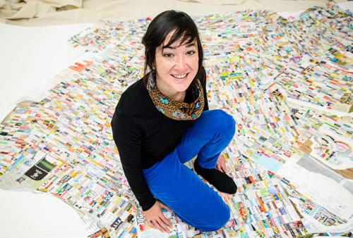
A Prospect Heights artist has made a giant map of the borough out of litter she collected on Brooklyn streets. But the creator said she is not trying to trash Kings County — she wants to inspire viewers to take a closer look at Brooklyn’s streets, as she did.
“My hopes are that observers find inspiration to explore both the land we share and our relationships to it,” said Jennifer Maravillas.
Maravillas’s piece will be on display as part of “Mapping Brooklyn,” a new exhibition running across Bric House in Fort Greene and the Brooklyn Historical Society in Brooklyn Heights from Feb. 26.
The artist said she spent three years collecting enough trash for her 10-by-10 foot piece. The most common items she picked up were phone cards, shopping lists, religious texts and flyers, metro cards, parking meter slips, menus, and advertisements. But Maravillas said she avoided collecting too many versions of the same item, searching instead for distinct debris that represented the unique block it was plucked from.
“The very best moments of my process were when I found perfect pieces of trash — something that showed the culture of a place, the vernacular of a neighborhood,” she said.
“Mapping Brooklyn” will also feature cartographic creations from 17 other artists — including photography, drawings, sculptures, and interactive projects — displayed alongside actual maps from the Brooklyn Historical Society’s archival collection. These maps — which include a 1921 “red scare” map of suspected radical “racial colonies” and a 1940 map of Brooklyn blocks colored by their average monthly rent — can tell us a lot more about the borough than just how to get to the subway, a representative from the Brooklyn Historical Society said.
“The maps have all sorts of implications or historical attitudes and assumptions about the world,” said Deborah Shwartz, president of the Brooklyn Historical Society.
Maravillas’s piece focuses on Brooklyn as a whole, but other participating artists were even more hyper-local in focus, honing in on a single neighborhood or an aspect of a neighborhood. One piece is a fusion of drawing and cartography that creates a poetic story exploring the history hidden in the area surrounding Prospect Park, while another explores the history of graffiti in Bushwick, said Elizabeth Ferrer, Bric’s curator of contemporary art.
Less local but no less impressive, the show will also host artist Joyce Kozloff’s 2000 work “Targets,” a nine-foot walk-in globe painted with aerial maps of areas around the world that have been bombed by the US military.
“Mapping Brooklyn” at Bric House [647 Fulton St. at Ashland Place in Fort Greene, (718) 855-7882, www.brica