
Slowest bus in the borough? There’s an app for that.
Phone-wielding B63 straphangers can now track their snail-like bus along its Bay Ridge-to-Brooklyn Heights route, thanks to a satellite-guided system unveiled on Wednesday by the Metropolitan Transportation Authority.
And unlike the B63, the system works flawlessly.
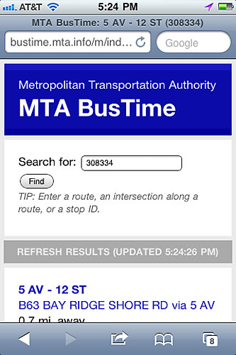
When The Brooklyn Paper used the system, called Bustime, in front of a stop on Fifth Avenue and Dean Street, our cellphone told us exactly where the bus was, allowing commuters to know if they had time to grab a cup of coffee or whether they should pack it in and walk.
“It makes sense,” said Laurence Beauvais, a tourist from Canada, where such technology is already popular. “We could be waiting inside a Starbucks instead of out here.”
The pilot program — which cost the MTA $500,000 — uses a computer chip planted inside the buses to help commuters gauge when to show up at the stops.
Users can download the free app at bustime.mta.info. The less technologically advanced passengers can also text the MTA with a six-digit code displayed at each bus stop and receive a message back about the whereabouts of the bus.
The MTA said it chose the B63 not because it is always on the list of the slowest buses in the borough, but because the agency “wanted a route with a good amount of ridership” and buses that are already compatible with the tracking software, said agency spokesperson Judie Glave.
If successful, the program will be expanded across the city.