
Marine Park is very well-coordinated.
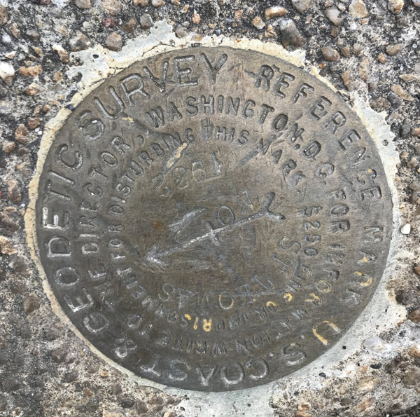
A little-noticed location marker in the neighborhood sheds light on how geographic coordinates in the country are determined. The National Geodetics Survey, which defines latitude and longitude lines across the country, placed a marker on a curb at the corner of Flatbush Avenue and E. 46th Street in 1932. The marker mostly goes unnoticed, but it caught one lifelong resident’s eye in February.
“I grew up on E. 46th Street and never saw this thing,” said Marine Parker Ken Rogers. “Here’s this thing’s been sitting here all these years. Who ever sees that?”
The National Geodetic Survey has placed around 500,000 such markers throughout the country, and they are used to designate established latitude and longitude positions, or known points of elevation, according to National Geodetic Survey official Dan Martin. This allows mappers, surveyors, engineers, and others to make maps using a common coordinate system, which helps makes precision maps standardized for all, he said.
“It allows anyone to relate their surveys,” said Martin.
The nearly four-inch-wide marker is noticeably worn down, which is understandable considering its 85-plus years of age. It bears the name of the U.S. Coast and Geodetic Survey, the predecessor to the National Geodetic Survey, as well as St. Thomas, referring to the St. Thomas Aquinas church on Hendrickson Street.
It also says that tampering with the marker will result in a $250 fine — which in 1932 was worth what $4,221 is today.
The National Geodetic Survey put this marker there as a geographical reference to a marker at the church .33 miles away, and it served to help surveyors and mapmakers position their equipment for measurements, according to Martin.
“A surveyor would set their equipment up on St. Thomas which has a known latitude and longitude, sight the azimuth mark to establish a known bearing, and then begin a survey,” he said.
The marker Rogers noticed is officially known as St. Thomas No. 2 azimuth. “Azimuth” means an angular measurement in a coordinate system such as the one the National Geodetic Survey maintains. “Geodetic” refers to a branch of mathematics used in large-scale measurements.
There are several other markers in the area, including one near the intersection of Flatbush Avenue and Avenue U, according to Martin.
The survey engraved the threat of fine on the marker to serve as a deterrent more than a practical penalty, and the figure has not been adjusted for inflation.
“I have personally never heard of this fine, penalty being enforced,” said Martin. “I believe it is still on the books as originally written.”
More than just the fine will be out of date soon — the National Geodetic Survey is in the process of moving to a GPS-based system from the physical markers in Marine Park and elsewhere, because markers can move over the years, Martin said.
“They aren’t necessarily stable. Who’s to say it hasn’t moved since 1932?” he said. “It could move if it’s not secure in the bedrock, cause of frost, or due to damage from construction.”
The 1930s, when the National Geodetic Survey placed the marker, was a period marked by a lot of development in Marine Park as it transitioned from an agricultural to a residential area.
Rogers said St. Thomas No. 2 azimuth sits on a damaged curb near a bus stop, which is only reason he spotted it in the first place.
“It’s funny, I was waiting for the bus,” he said. “It’s so small you don’t notice it.”