
The Metropolitan Transportation Authority stuck its foot in a contentious debate that’s divide Brooklynites for decades — where does Park Slope end and Greenwood Heights begin?
A recently installed map at the 25th Street subway station places the bougie brownstone neighborhood well below the Prospect Expressway, where the moniker “Park Slope” is labeled confidently, despite the area’s namesake greenspace, Prospect Park, ending at 15th Street and Greenwood Cemetery taking over as the most prominent landmark.
The faux pas sparked a lively debate on the Brooklyn sub-Reddit page, where user CallYaMuthaAlreddie claimed that 15th Street remains Park Slope’s definitive southern boundary.
“This map is wrong,” wrote the Reddit user. “Park Slope ends at 15th street, where the park ends. There’s no park to slope from at Prospect Avenue.”
The MTA’s map also refutes the Brooklyn Paper newsroom’s handy map of the borough, where Greenwood Heights is located south of the expressway, and which this publication holds as the definitive arbiter of neighborhood boundaries — if only because it’s what we’re used to.
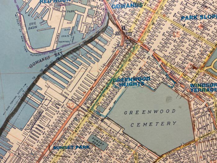
However, a spokesman for the MTA said that the Authority’s in-house cartographers base their maps on city data, claiming that it isn’t transit bigwigs who extended Park Slope south of 15th Street, but rather the de Blasio Administration.
“These maps are based on data provided by and used consistently by New York City government and we’re not in a position to change the City’s municipal map,” said authority spokesman Shams Tarek.
We reached out to the city for clarification and will update with their response.
Regardless of where you stand on the Park Slope/Greenwood Heights divide, the MTA’s map bears one undeniable mistake — the Con-Edison Greenwood Substation located on Fifth Avenue between 23rd and 24th streets has been conspicuously relocated by the Authority map makers, who place the block-long station on Sixth Avenue between 22nd and 23rd streets.